Watch and warning over for 4/21/21


I’m more worried about the cold air behind this storm. I just planted azaleas and hydrangeas on Sunday.

The NWS has issued a Severe Thunderstorm Watch for the entire region from now until 6:00 pm.
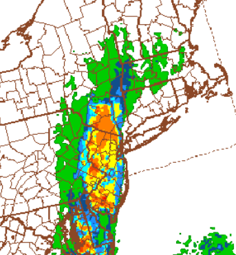
There is a line of moderate to heavy precipitation running north north-east from Lancaster PA to the Catskill and moving east, arriving in our area around 2:00 pm. It is likely there will be small short thunderstorms in this line when it arrives. Some models also show a second, weaker storm, also small and quick, about an hour later.
SEVERE THUNDERSTORM WARNING
National Weather Service New York NY141 PM EDT Wed Apr 21 2021
The National Weather Service in Upton NY has issued a
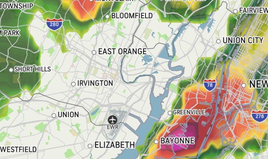
* Severe Thunderstorm Warning for... Hudson County in northeastern New Jersey... Passaic County in northeastern New Jersey... Union County in northeastern New Jersey... Bergen County in northeastern New Jersey... Essex County in northeastern New Jersey... Southern Orange County in southeastern New York... Rockland County in southeastern New York...
* Until 245 PM EDT.
* At 141 PM EDT, severe thunderstorms were located along a line extending from near Unionville to near Cloverhill, moving east at 35 mph.
HAZARD...60 mph wind gusts.
SOURCE...Radar indicated.
IMPACT...Expect damage to trees and power lines.
* Severe thunderstorms will be near... Warwick and Florida around 150 PM EDT. Goshen around 155 PM EDT. Chester around 200 PM EDT. Monroe around 205 PM EDT. Harriman around 210 PM EDT. Plainfield around 220 PM EDT. West Point and New Windsor around 225 PM EDT. Clark around 230 PM EDT. Linden around 240 PM EDT. Bayonne around 245 PM EDT.
PRECAUTIONARY/PREPAREDNESS ACTIONS...
For your protection move to an interior room on the lowest floor of abuilding.
&&
LAT...LON 4059 7446 4067 7440 4067 7446 4076 7436 4090 7434 4090 7427 4097 7428 4105 7445 4104 7450 4109 7450 4120 7437 4135 7461 4150 7399 4140 7395 4125 7397 4113 7389 4070 7402 4065 7406 4065 7419 4059 7420TIME...MOT...LOC 1741Z 257DEG 29KT 4132 7448 4044 7481
HAIL...<.75INWIND...60MPH
$$


looks like some bad pockets out there - if you look at the futurecast - it appears to lose some strength as it gets closer to us.
It's predicting 2:20 to be the worst - then another system around 3:10 - let's see how accurate this is.
that was weird. Got a call from my son at the W.O. Recycling Center and he said it was hailing. I'm over by St. Barnabas and there's nothing. It was windy for a few minutes and a bit of rain, but it's very calm now.
Looks like Maplewood is going to be spared from the worse part of this line. Should be interesting to see how fast the temperature dips after this rolls through.

I got in and out of the dog park around 2. Saw the black clouds to the west but nothing happened there or at home upon return. Did we beat it?

Rentals

Sponsored Business


Promote your business here - Businesses get highlighted throughout the site and you can add a deal.

There is a fair possibility that tomorrow afternoon's rainstorm will include some nested thunder and gusty winds. This will be a fast moving system, passing through in just a couple of hours, most likely between 1:00 and 4:00 in the afternoon. If we do get one of the thunderstorms, expect a brief period of heavy rain with gusts in the 30 mph range. Otherwise, moderate rain for two to three hours.