There is still a great deal of uncertainty about the upcoming storm this weekend. The main energy for the storm is still offshore in the Pacific, where it is difficult to measure. By this afternoon we should have on shore readings. We will have a much better grasp of what is happening by tomorrow.
As of now, the storm looks like an Appalachian runner, tracking from south to north with the center passing to our west in Pennsylvania. We are seeing an inch to even an inch and a half of water. Uncertainty about the storm's actual track means we don't know the tempurature profile, so as a result we don't yet know the form the precipitation is likely to take. If the track shifts east, the mix could be more snow than rain.
If the current model consensus holds, we could see a quick dump of heavy snow Sunday night that changes through sleet to rain by Monday morning. It could run back through sleet to snow before ending late Monday. This is very speculative. Anyone giving you a more concrete forecast at this point is talking through their hat.
Lots of interesting weather this weekend but I won't bury the lede. As of this morning, the Sun - Mon storm is still a snow into sleet into rain event, with the a front end few inches being washed away by morning. A lot can change but as of now it has not.
Before that, though, expect blustery gusty winds this afternoon, and bitter cold Friday through Saturday and into Saturday night, with overnight windchill Sat below zero.
Some details. A clear and cold airmass should move in tomorrow on a strong breeze. When the wind dies down, the cold will settle in, with lows Saturday night in the single digits. Sunday we expect a warmer onshore breeze under overcast skies. The center of the storm looks like it should run up the mountains and pass just west of us, so that warm onshore breeze will keep snow totals down. Likely to see a front end thump of snow that changes to sleet and rain Sunday night, perhaps starting between 7 and 10 pm with the changeover after midnight. If this scenario holds, we could be dry slotted by morning, with the storm continuing both out to sea and in Eastern PA while we get nothing. Although this feature has been showing up on a lot of the modeling for over 24 hours, we are still over three days out and everything could change. Otherwise, rain could continue until midday Monday. Either way, any accumulating snow that has fallen should wash away Monday morning.
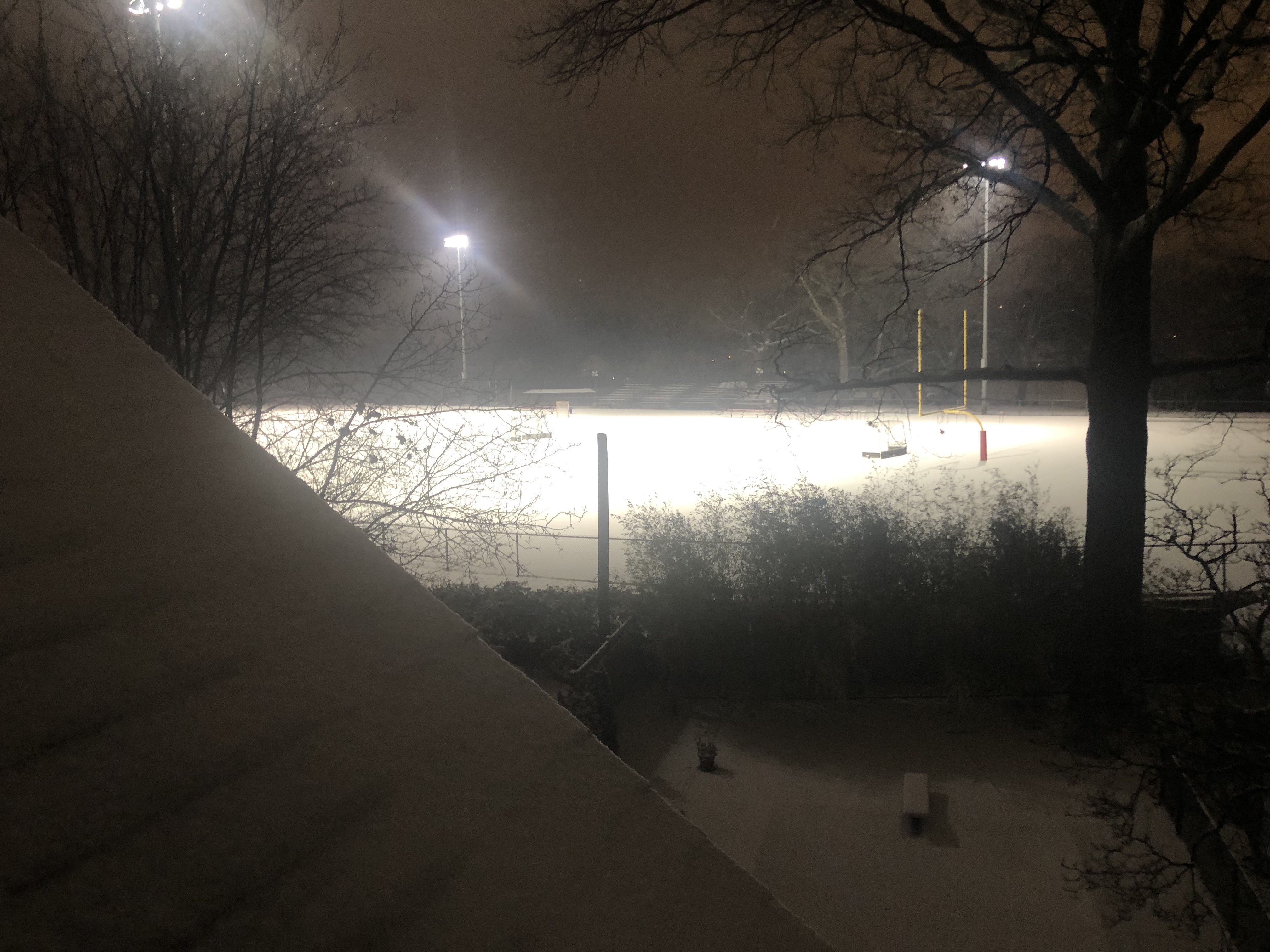
Quite a little storm tomorrow night, but not a lot of snow
Forecast remains on track for a storm to run up the east coast from the shore through the eastern mountains.
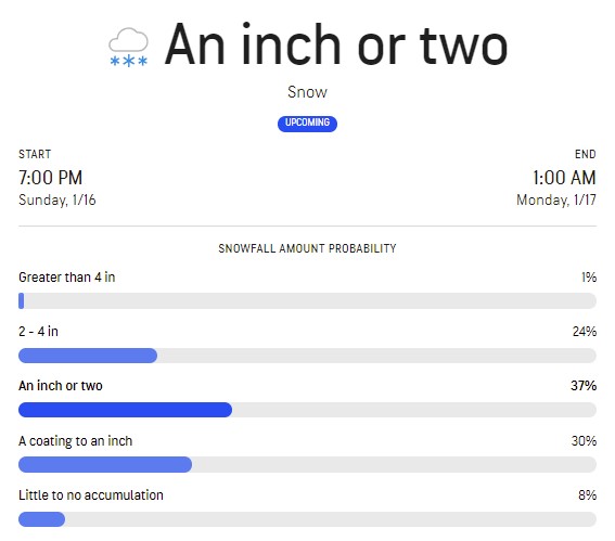
In MAPSO, the storm should arrive as snow Sunday evening between 6 and 8. Snows for awhile, possibly 1 - 3 inches, then around midnight changes over through sleet and freezing rain to all rain, heavy at times. There could be a glaze of ice during the changeover period that would make travel difficult but that would wash away by morning.
Rain should taper off Monday morning. There is a chance things could end midday Monday with light snow.
Gusty winds after midnight Sunday - Monday could reach Advisory levels with gusts in the 40s.
Max, it amazes me how often storms or winds you’ve mentioned seem to mirror what’s happening here on the Gold Coast or in the Top End in cyclone/ monsoon seasons.
Early this morning (Sunday, 16th, I’m talking around 2am) very fierce electrical storm cells merged and got really nasty. Our electricity kept shutting off, 40 mins later it was on for 5 mins then off, repeat the cycle… now at 6:35 am it’s fresh, cool and breezy. 31.2mm fell here; currently 30% humidity but further storms predicted as we heat to 30°C. It’s currently 21°, and the breeze is SW-W up to 30km/hr. Actually, it’s probably nice for sailing right now but rough for surfing or paddleboarding.
Forecast on track for a mostly rain and wind storm tonight.
Snow likely to overspread the area starting around 6 - 7 pm this evening. Snow changes through sleet to rain before midnight. Freezing rain possible for a brief period although unlikely and would be washed away shortly. Travel could be challenging between 7 and midnight in some areas. Rain, heavy at times, should end by early morning as the models show us in a persistent dry slot between heavy rain on Long Island and snow in the Poconos. Chance of a little snow, at most 1/2 to 1 inch, later in the day Monday
Winds pick up around midnight Sunday - Monday morning, with a brief period where gusts may hit the 40s. Rest of the day Monday winds 10 - 20 with gusts to 25.
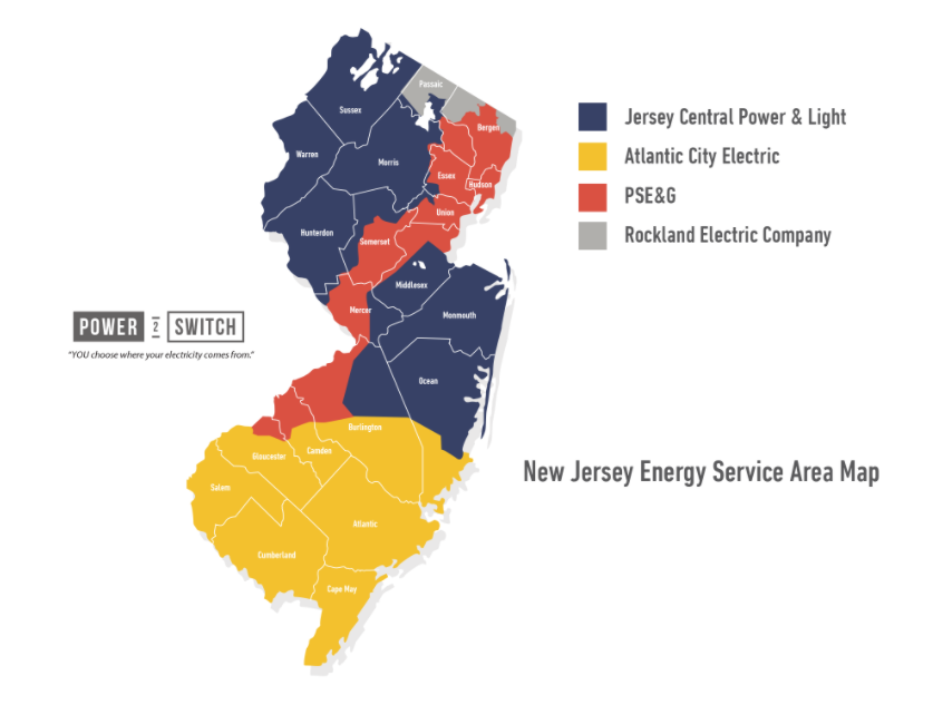
I would not be surprised if there are more PSE&G customers than all the other areas combined.
maybe they do have the most customers, if you figure out how many people live in that swath of land right down the middle. Like Jamie said it looks like a ‘gerrymandered’ district..
I would not be surprised if there are more PSE&G customers than all the other areas combined.
maybe they do have the most customers, if you figure out how many people live in that swath of land right down the middle. Like Jamie said it looks like a ‘gerrymandered’ district..
Rate Counsel | About Public Service Electric & Gas (PSE&G) Summary: PSE&G is New Jersey's largest utility and is a regulated utility delivering gas and electric service to areas of New Jersey in which about 70% of the population reside. The company has 2.1 million electric customers and 1.7 million gas customers.
That happened to us also, but I wasn't following MOL then and didn't see the post until just now. (We were watching TV and it took out our FIOS TV for a few minutes so we definitely noticed it at the time.)


There is still a great deal of uncertainty about the upcoming storm this weekend. The main energy for the storm is still offshore in the Pacific, where it is difficult to measure. By this afternoon we should have on shore readings. We will have a much better grasp of what is happening by tomorrow.
As of now, the storm looks like an Appalachian runner, tracking from south to north with the center passing to our west in Pennsylvania. We are seeing an inch to even an inch and a half of water. Uncertainty about the storm's actual track means we don't know the tempurature profile, so as a result we don't yet know the form the precipitation is likely to take. If the track shifts east, the mix could be more snow than rain.
If the current model consensus holds, we could see a quick dump of heavy snow Sunday night that changes through sleet to rain by Monday morning. It could run back through sleet to snow before ending late Monday. This is very speculative. Anyone giving you a more concrete forecast at this point is talking through their hat.