10/26 rain thread

Mon Oct 25th morning update
Changes to the forecast from yesterday:
Main rain arrives later, more likely after midnight, and continues into Tues night.
This remains a difficult forecast. The models are having trouble defining the storm, and disagree about whether there are two lows or one combined center. If the storm does form a single center, though, it will more likely happen to our east and move north into New England.
Forecast:
Rain, light during the day today, becoming heavy after midnight tonight. Heavy rain is likely to continue through Tuesday and into Tues night. Slight chance of some thunder with heavier rain during thunderstorms. 2 - 4 inches total rain, more if more thunderstorms develop.
Flash Flood Watch in effect tonight through Tues.
Wind, Tuesday through Wednesday morning. It looks like the worst of the winds will just miss us to the north and east, including the shore, Long Island, and New England. Here expect steady 15- 20 with gusts to 30 mph. There is upside depending on storm intensity and track Tues and Wed.
Mon 10/25 Evening Update
Yuck.
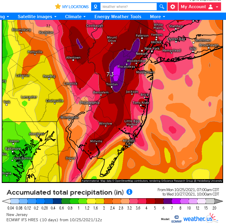
There is still significant disagreement between and among the models about this storm. The bottom line is that a 3 - 4" forecast rainfall from midnight tonight until early evening tomorrow is the most prudent, but there are indications (particularly on the Euro model) that we could get as much as 6 - 7" which is why Gov. Murphy is taking no chances and has declared a state of emergency.
The ending point of the rainfall is also unclear. Rain will taper off tomorrow afternoon, but whether that means early afternoon or early evening is very much in doubt.
This is a lot of rain. The worst of Ida was the very heavy, 3"/hour dump, which is very unlikely with this set up. There is however a good chance of periods of 1"/hour, especially if we get any thunderstorms embedded. This could lead to street and field flash flooding, and minor small stream flooding is not out of the question.
Other than the very wide spread in rainfall forecast, the rest is on track in terms of timing. It looks like we will dodge the worst of the winds (as I mentioned this morning, 10 - 15 mph with gusts to about 30 mph, mostly Tues afternoon through Wed after the bulk of the rain).
The good news is that Friday's storm is looking like a non-event, a rainy day more than a storm.
Warning, from here down the post gets a bit geeky.
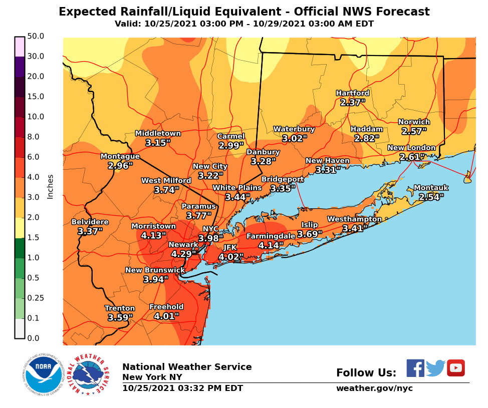
Below are two rain maps that give you an idea of the spread in the forecast. The one from the NWS is based mostly on the American GFS model. The other is raw output from the Euro. The American model suite supports the NWS projections, and I am also leaning towards a GFS/NAM solution, but I don't want to just ignore the Euro. The weather weenies on the message boards are very excited about the British UKMet model, but to my eye it looks like an outlier. The Euro and GFS have both undergone major upgrades since last winter, and it will be interesting (to weather nerds, at least) to see how they handle a complex system like this. It should help us understand the winter storms a bit better this year.
If WxNut check into this thread, I would love to hear his thoughts on the upgrades and the differences in the ways they are handling this system.


Tues 10/26 morning
Nor'easter
Rain, heavy at times, steady until early afternoon then more intermitant. Chance of thunderstorms all day.
Wind begins to pick up later in the day. By tonight, steady 15 - 20 mph with gusts to 30 mph.
Total rain 3 - 5 inches
There is a Flood Advisory due to the large amount of rain (about 2") that has already fallen until 8:15 this morning. Expect road and small stream flooding in the usual areas.
There is a Flash Flood Watch until 6:00 pm.
There was a very long siren this morning around (checks watch) really f***ing early. Was that for the flood watch?
8:00 am rainfall reading is 2.92" in Eastern Maplewood
From the NWS:
Flash Flood Warning
Flash Flood Warning
NJC003-013-017-031-039-261330-
/O.NEW.KOKX.FF.W.0050.211026T1139Z-211026T1330Z/
/00000.0.ER.000000T0000Z.000000T0000Z.000000T0000Z.OO/
BULLETIN - EAS ACTIVATION REQUESTED
Flash Flood Warning
National Weather Service New York NY
739 AM EDT Tue Oct 26 2021
The National Weather Service in Upton has issued a
* Flash Flood Warning for...
Bergen County in northeastern New Jersey...
Essex County in northeastern New Jersey...
Hudson County in northeastern New Jersey...
Passaic County in northeastern New Jersey...
Union County in northeastern New Jersey...
* Until 930 AM EDT.
* At 739 AM EDT, Doppler radar indicated heavy rain across the
warned area. Between 1 and 2 inches of rain have fallen.
Additional rainfall amounts of 1 to 2 inches are possible in the
warned area. Flash flooding is ongoing or expected to begin
shortly.
HAZARD...Flash flooding caused by heavy rain.
SOURCE...Radar.
IMPACT...Flash flooding of small creeks and streams, urban
areas, highways, streets and underpasses as well as
other poor drainage and low-lying areas.
* Some locations that will experience flash flooding include...
Newark, Jersey City, Paterson, Elizabeth, Passaic, Bayonne, Wayne,
Hoboken, Plainfield, Bloomfield, Hackensack, Linden, Orange,
Bergenfield, Paramus, West Milford, Ridgewood, Summit, Lyndhurst
and Millburn.
PRECAUTIONARY/PREPAREDNESS ACTIONS...
Turn around, don`t drown when encountering flooded roads. Most flood
deaths occur in vehicles.
Be aware of your surroundings and do not drive on flooded roads.
Excessive runoff from heavy rainfall will cause flooding of urban
areas, highways, streets and underpasses as well as other drainage
areas and low lying spots.
Please report observed flooding to local emergency services or law
enforcement and request they pass this information to the National
Weather Service when you can do so safely.
&&
LAT...LON 4108 7450 4120 7437 4100 7389 4071 7402
4068 7410 4066 7407 4067 7411 4065 7408
4065 7419 4060 7423 4060 7446 4066 7440
4067 7446 4075 7436 4091 7433 4091 7427
4100 7430 4102 7443 4105 7445 4104 7450
FLASH FLOOD...RADAR INDICATED

mrincredible said:
There was a very long siren this morning around (checks watch) really f***ing early. Was that for the flood watch?
I heard that too. I thought it was a tornado warning, but my phone didn’t alert and it wasn’t really windy.
Incredibly, there are still disagreements between the model suites about where this storm is headed this afternoon (10/26/21).
There is a timing disagreement, mostly. The American models have a dry afternoon followed by moderate rain around 8:00 this evening for a couple of hours. The European models are faster, with the heavy rain arriving in the afternoon, and wetter.
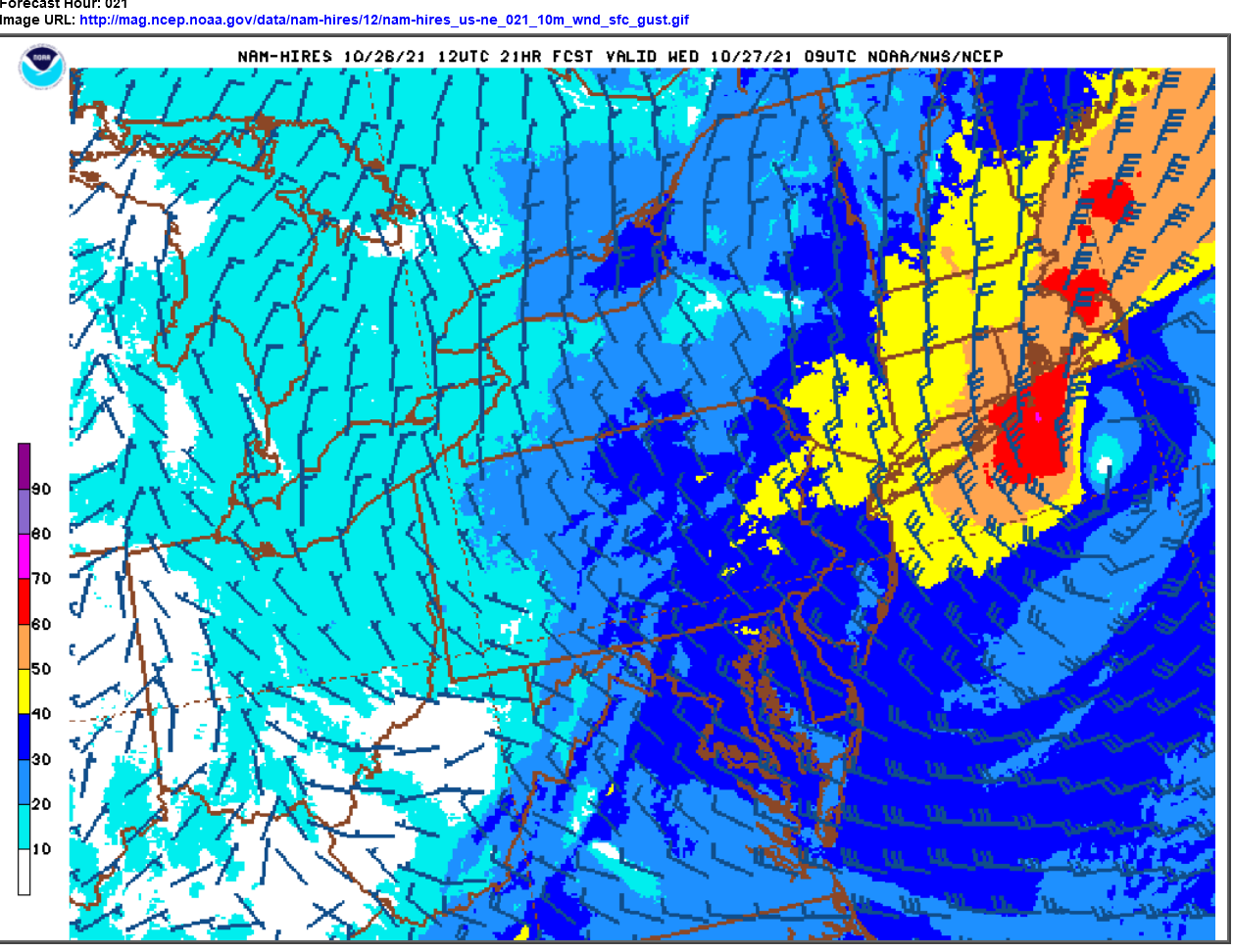
The wind forecast has picked up a bit. Winds this afternoon, steady 10 - 15 mph through the overnight but now the gusts are 25 - 35 mph, possibly as high as 40 mph, about 5 - 10 mph more than this morning's forecast.
Rain so far just under 3.5"
Map below is the wind and gust output from the Hi-Res NAM model, projected for the peak winds at 4:00 am Wed morning.

Thanks, Max! Oh, and I enjoyed reading the Village Green spotlight today. 

Still some rain and wind to come this evening, Tues 10/26
Rain will redevelop between now and 8:00 and continue most of the night. Rain could be heavy at times but do not expect a repeat of last night. Expecting 1 - 2" additional rain between now and mid-morning tomorrow.
The wind is showing up a bit later than expected, and I am backing down to my original 10 - 15 steady with 30 mph gusts, mostly in the early hours of Wednesday.
What made (and makes) this such a difficult forecast has been the presence of two low pressure systems interacting. I suspect the models had some difficulty differentiating but I am not an expert of how they work so I should probably not speculate. The lesser of the two lows has been parked over northern NJ while the other, major low is out southeast of the twin forks. The bigger low is now swinging back in towards New England (this was forecast) and will back the rain shield into our area again tonight, with the results I mentioned above.

Featured Events


Sponsored Business


Promote your business here - Businesses get highlighted throughout the site and you can add a deal.

Happy Fall. As of now, Sunday October 24, it looks like we are scheduled for our first (and second) nor'easters of the season.
The NWS has issued a Flash Flood Watch for our area from Monday evening through Tuesday afternoon.
All major models are showing a large and powerful storm will likely form in the Atlantic and pass to our east Monday night and Tuesday. Main affected areas will be Long Island and New England, but we can and should expect rain and wind in our area from Monday evening through Tuesday, with wind possibly continuing into Wednesday morning.
There is some disagreement in the models as to how much rain and wind to expect. A reasonable forecast right now would be 1 - 4" of rain over the 18 hour period, but I suspect that 3+" is more likely. If thunderstorms develop, then some of the difference between the models could fall in cloudbusts of an inch an hour, and these would be the most likely (but not the only) source of a flash flood.
The wind is also likely to be an issue with the storm. In fact, I am more confident with the wind forecast than the rain amount. The wind should pick up more on Tuesday in the afternoon, with a steady breeze of 15 - 20 mph and gusts, particularly on Wednesday, of 30 - 40 mph. There is also a possibility of gusting during any thunderstorms that develop Monday night.
Please note the difference between a flash flooding situation (such as this storm) and a flood situation. This is not expected to be a flooding situation (which refers to river flooding). Flash flooding around here tends to be street and field flooding. The greatest danger is to drivers who underestimate the 'puddle' they see on the road (or overestimate their vehicle's ability to navigate said 'puddle') and drive into a flooded area. There is more information in the NWS watch bulletin I will post below.
Regarding Friday, it is way too early to early to forecast that storm. I promise I will follow up on it when we know something more certain.
~~~~~~~~~~~~~~~
From the NWS:
Flash Flood Watch
National Weather Service New York NY
258 PM EDT Sun Oct 24 2021258 PM EDT Sun Oct 24 2021
...FLASH FLOOD WATCH IN EFFECT FROM MONDAY EVENING THROUGH TUESDAYAFTERNOON...
The National Weather Service in Upton has issued a Flash Flood Watch for portions of southern Connecticut, northeast New Jersey and southeast New York, including the following areas, in southern Connecticut, Northern Fairfield, Northern Middlesex, Northern New Haven, Northern New London, Southern Fairfield, Southern Middlesex, Southern New Haven and Southern New London. In northeast New Jersey, Eastern Bergen, Eastern Essex, Eastern Passaic, Eastern Union, Hudson, Western Bergen, Western Essex, Western Passaic and Western Union. In southeast New York, Bronx, Kings (Brooklyn), New York (Manhattan), Northeast Suffolk, Northern Nassau, Northern Queens, Northern Westchester, Northwest Suffolk, Orange, Putnam, Richmond (Staten Island), Rockland, Southeast Suffolk, Southern Nassau, Southern Queens, Southern Westchester and Southwest Suffolk.
* From Monday evening through Tuesday afternoon.
* A rapidly developing low pressure system south of Long Island will likely produce heavy rainfall across the region. Rainfall totals of 2 to 4 inches with locally higher amounts are possible. Rainfall rates may exceed one inch per hour at times.
* Heavy rain may produce areas of flash flooding.
PRECAUTIONARY/PREPAREDNESS ACTIONS...You should monitor later forecasts and be prepared to take action should Flash Flood Warnings be issued.