Could be very wet next weekend (10/28)

With a healthy dose of influence from Hurricane Willa that will make landfall as a Cat 3/4/5 in Western Mexico.


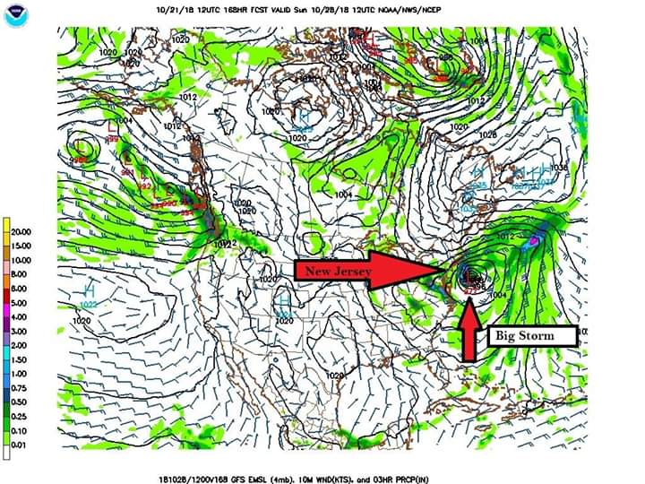
Although model track and intensity differences persist this morning, there is a more consistent signal overall to suggest a rainy, windy weekend.
Models are coming into better agreement on a rainy windy weekend starting Friday night. Sunday may have some dry periods, but the exact track of the storm is still somewhat uncertain. Do not expect serious flooding at this time. Winds in the 20s and gusty.


sprout said:
Do we know approximately what time rain might start Friday night?
Still hard to say. Right now the NWS is saying after midnight.

darn. Westfield is doing Addamsfest all weekend which seemed like it was going to be a really cool event. Kids were super-excited about it.
Weekend update: Although Saturday is almost certainly a washout, rainy with periods of heavy rain and breezy with a bit of gusting, this does not look to be the major storm we were worried it might be. Rain still forecast to arrive mostly after midnight Friday. Sunday the showers may even hold off until evening.

max_weisenfeld said:
Sunday the showers may even hold off until evening.
So, the Giants' game will likely only be a washout based upon performance, not weather.


Status quo, pretty much. Go with the forecast ridski linked to above.

So, is there some nearby area that is just going to get crushed by this storm? I ask because I have gotten warnings from the power company, the phone company, my kids soccer league and the Montclair Farmers Market but, when I look at the forecast, it doesn't seem like much at all.

so, weather guys, when I zoom out on my weather radar, it looks really bad out over the Atlantic.
Would we be getting pounded if this had tracked a bit more to the west???
Best Regards.
Ron Carter
rcarter31 said:
so, weather guys, when I zoom out on my weather radar, it looks really bad out over the Atlantic.
Would we be getting pounded if this had tracked a bit more to the west???
Best Regards.
Ron Carter
Yes
Thanks Max and on this very sad day thanks as well for sharing info about the observances after Saturday's Horror.
-Ron Carter

Featured Events
-
Stephen Whitty Presents - Hometown Movie Stars: The Celebrated Actors Of CHS
May 6, 2024 at 7:00pm


There is a growing signal in the models for a storm next weekend. While it is too early to plot the track of the storm, it is strongly suggested that the storm, should it pass over us, would be wind and rain. Snow and ice are unlikely.
The effects of storms of this sort, which track up the coast, are strongly determined by the track; a shift of only 50 miles can mean the difference between a bit of rain and a nor'easter. Also right now the models are swinging 24 - 48 hours from run to run, so next weekend is the most accurate eta I can responsibly give.
I will post when things become clearer.